Chapter XIII
THE NAHUA
TRIBES.
Early Spanish discoveries in Mexico—The
Nahua tribes defined—Climate of Mexico—The Valley of
Anahuac—Ruins at Tezcuco—The hill of
Tezcocingo—Ruins at Teotihuacan—Ancient
Tulla—Ruins in the province of Querataro—Casa Grandes
in Chihuahua—Ancient remains in Sinaloa—Fortified
hill of Quemada—The Pyramid of Cholula—Mr.
Bandelier's investigations at Cholula—Fortified hill at
Xochicalco—Its probable use—Ruins at Monte
Alban—Ancient remains at Mitla—Mr. Bandelier's
investigations—Traditions in regard to Mitla—Ruins
along the Panuco River—Ruins in Vera Cruz—Pyramid of
Papantla—Tusapan—Character of Nahua Ruins.
 THE ships of the Spanish
admiral came to anchor before the Island of San Salvador, he had
indeed discovered a "New World." It was inhabited by a race of
people living in a state of society from which the inhabitants of
Europe had emerged long before the dawn of authentic history. The
animal and plant life were also greatly different from any thing
with which they were acquainted. The Spaniards little suspected
the importance of their discovery. Columbus himself died in the
belief that he had simply explored a new route to Asia. A quarter
of a century elapsed after the first voyage of Columbus before an
expedition coasted along the shores of Mexico. This was the
expedition of Juan De Grijalva, in 1518. He gave a glowing
description of the country he had seen, which "from the beauty
and verdure of its indented shores, and the lovely appearances of
its villages, he called 'New Spain.'"1
This was followed, in the year 1519, by the
history-making expedition of Cortez. The scene of his first
landing was about forty miles south of the present town of Vera
Cruz, but to this place they soon removed. At his very first
landing-point he learned of the existence of what he was pleased
to call a powerful empire, ruled by a most valiant prince. The
accounts the Indian allies gave him of the power and wealth of
this empire inflamed the imagination of Cortez and his followers.
This was an age, we must remember that delighted in tales of the
marvelous; add to this the further fact that Cortez was not, at
the beginning of his expedition, acting with the sanction of his
royal master; indeed, his sailing from the island of Cuba was in
direct violation of the commands of the governor. It was very
necessary for him to impress upon the court of Spain a sense of
the importance of his undertaking.
Certain it is that the accounts that have been
handed down to us, though read with wonder and admiration, though
made the basis on which many writers have constructed most
glowing descriptions of the wonders of the barbaric civilization,
which they would fain have us believe, rivaled that of "Ormus and
of Ind," are to-day seriously questioned by a large and
influential portion of the scientific world. We have another
point to be considered that is of no little weight, as all candid
men must admit that it would influence the opinions the Spaniards
would form of the culture of the Indians. As the man of mature
years has lost the memory of his childhood, so have the civilized
races of men lost, even beyond the reach of tradition, the memory
of their barbaric state. The Spaniards were brought face to face
with a state of society from which the Indo-European folks had
emerged many centuries before. They could not be expected to
understand it, and hence it is that we find so many contradictory
statements in the accounts of the early explorers; so much that
modern scholars have no hesitation in rejecting.
The main tribe of the empire which Cortez is
said have overthrown is known to us by the name of the Aztecs;
but as this name properly denotes but one of many tribes in the
same state of development, it is better to use a word which
includes all, or nearly all, of the tribes that in olden times
had their home in the territory now known as Mexico. Careful
comparisons of the various dialects of ancient Mexico have shown
that, with the exceptions of some tribes in Vera Cruz, they all
belonged to one stock-language; and so they are collectively
known as the Nahua tribes.2
We wish now to inquire into the culture of
this people, to see how much of the strange story that the
Spaniards have to tell us has a reasonable foundation. We will
state frankly that, though the literature on this subject is of
vast proportions, yet it is very far from being a settled field.
All accounts of the early explorers of the strange scenes,
customs, and manners of the inhabitants, when they were first
discovered, are so intermixed with self-evident fables, and
statements that are undoubtedly exaggerations, that we have a
most difficult task before us. We will first examine the
antiquities of this section, compare them with those found in
more northern regions, and then examine the statements of the
early writers as to the customs of the people. We do not propose
to do more than to follow after our leaders in thought, and try
to make plain the conclusions to which they have arrived. We are
not to deal wholly with a prehistoric people, though their origin
is unknown. What we desire to do is to clear away the mists of
three and a half centuries, and to catch, if possible, a glimpse
of what was probably the highest development of prehistoric
culture in North America just before the arrival of the
Spaniards.
Mexico was surely a land well adapted to the
needs of a prehistoric people. Along the coasts the ground is
low. This constitutes what is known as the "Hot Country."3 The greater part of Mexico consists of
an elevated table-land, which rises in a succession of plateaus.
As we leave the coast region and climb the plateau, we experience
changes of climate. If it were level, it would have mainly a
tropical climate, but owing to the elevation we have just
mentioned, it has mainly a temperate climate. The whole plateau
region is cut up with mountains. The Sierra Madre, on the west,
is the main chain, but numerous cross-ranges occur. The result
is, a greater part of Mexico abounds in fertile, easily defended
valleys—just such localities as are much sought after by a
people in barbaric culture, constantly exposed to the assaults of
invading foes.4
We may as well pass at once to the valley of
Anahuac, the most noted in all the region, and learn of the
antiquities of this central section. It is in this valley that
the capital of the Mexican Republic is situated. All travelers
who have had occasion to describe its scenery have been
enthusiastic in its praise. The valley is mountain-girt and
lake-dotted, and in area not far different from the State of
Rhode Island. On one of the principal lakes was located the
Pueblo of Tenochtitlan, the head-quarters of the Aztecs, commonly
known as the City of Mexico. When Cortez first stood upon the
encircling mountains, and gazed down upon the valley, he saw at
his feet one of the most prosperous and powerful pueblos of the
New World.
This is not the place to recount the story of
its fall. Our present inquiry is concerned solely with the
remains of its prehistoric age. The enthusiastic Spaniards would
have us believe in a city of Oriental magnificence. We have no
illustrations of this pueblo. It was almost completely destroyed
by Cortez before its final surrender in August, 1521. It was then
rebuilt as the capital city of New Spain. Of course, all traces
of its original buildings soon disappeared. What we can learn of
its appearance is derived from the accounts of the early writers,
which we will examine in their proper place. After having
surveyed the entire field of ruins, we will be much better
qualified to judge of the vague statements of its former
grandeur. A few relics have, indeed, been found buried beneath
the surface of the old city. They illustrate the culture of the
people, as will be noticed further on.
Directly across the lake from the Pueblo of
Mexico was that of Tezcuco, the head-quarters of the second
powerful tribe of the Aztec Confederacy. Traces only are
recoverable of its former buildings. At the southern end of the
modern town were found the foundations of three great pyramids.
They were arranged in a line from north to south. Mr. Mayer says
of these ruins: "They are about four hundred feet in extent on
each side of their base, and are built partly of adobe and partly
of large, burned bricks and fragments of pottery."5 He tells us further that the sides of
the pyramids "were covered with fragments of idols, clay vessels,
and obsidian knives." From other discoveries, it would seem these
pyramids were coated with cement. The suggestion is made that on
one of these pyramids stood the great temple of Tezcuco, which,
an early writer tells us, was ascended by one hundred and
seventeen steps.
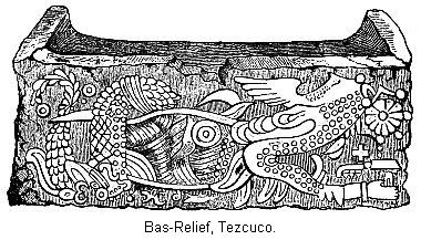
In another part of the town a sculptured block
of stone was found, of which this cut is given. "It appears to be
the remains of a trough or basin, and the sculpture is neatly
executed in relief. I imagine that it was designed to represent a
conflict between a serpent and a bird, and you can not fail to
remark the cross distinctly carved near the lower right-hand
corner of the vessel." Bullock, who traveled in Mexico in 1824,
has left a brief description of the ruins of what he calls a
palace. "It must have been a noble building. . . . It extended
for three hundred feet, forming one side of the great square, and
was placed on sloping terraces raised one above the other by
small steps. Some of these terraces are still entire and covered
with cement. . . . From what is known of the extensive
foundations of this palace, it must have covered some acres of
ground."6 This last statement is
doubtless exaggerated. From what we know of Indian architecture,
these ruins were doubtless long, low, and narrow, and placed on
one or more sides of a square, perhaps inclosing a court.
About three miles from the town of Tezcuco is
a very singular group of ruins. This is the Hill of Tezcocingo.
This is very regular in outline, and rises to the height of about
six hundred feet. A great amount of work has evidently been
bestowed on this hill, and some very far-fetched conclusions have
been drawn from it. Probably as notable a piece of work as any
was the aqueduct which supplied the hill with water, and this is
really one of the most wonderful pieces of aboriginal work with
which we are acquainted.
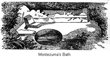
The termination of the aqueduct is represented
in our next cut. This is about half-way up the hill, right on the
edge of a precipitous descent of some two hundred feet. "It will
be observed in the drawing that the rock is smoothed to a perfect
level for several yards, around which seats and grooves are
carved from the adjacent masses. In the center there is a
circular sink, about a yard and a half in diameter and a yard in
depth, and a square pipe, with a small aperture, led the water
from an aqueduct which appears to terminate in this basin. None
of the stones have been joined with cement, but the whole was
chiseled, from the mountain rock."7 This has been called "Montezuma's
Bath," simply from the custom of naming every wonderful ruin for
which no other name was known after that personage; but this was
not a bath, but a reservoir of water.
From this circular reservoir the side of the
mountain is cut down so as to form a level grade, just as if a
railroad had been made. This grade winds around the surface of
the hill for about half a mile, when it stretches out across a
valley three-quarters of a mile wide, an elevated embankment from
sixty to two hundred feet in height. Reaching the second
mountain, the graded way commences again, and is extended about
half-way around the mountain, where it extends on another
embankment across the plains to a range of mountains, from which
the water was obtained.
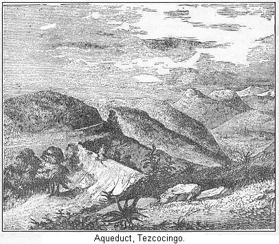
This cut represents the embankment crossing
the valley. Along the top of this way was laid the canals to
transport the water, made of an exceedingly hard cement of mortar
and fragments of pounded brick. It is estimated that nearly, if
not quite, as much labor was expended on this aqueduct as on the
Croton aqueduct that supplies New York City.8 This last statement is probably too
strong, but, considering that this work was accomplished by a
people destitute of iron tools, it is seen to be a most
extraordinary work. From what we have already learned, this hill
was evidently a very important place. On all sides we meet with
evidences that the whole of the hill was covered with artificial
works of one kind or another. On the side of the hill opposite
this reservoir was another recess bordered by seats cut in living
rock, and leading to a perpendicular cliff, on which a calendar
is said to have been carved, but was destroyed by the natives in
later days.9
Traces of a spiral road leading up the summit
have been observed. In 1824 Bullock (who, however, is not
regarded as a very accurate observer) "found the whole mountain
had been covered with palaces, temples, baths, hanging-gardens,
and so forth." Latrobe, somewhat later, found "fragments of
pottery and broken pieces of obsidian knives and arrows; pieces
of stucco, shattered terraces, and old walls were thickly
dispersed over its whole surface."10 Mr. Mayer, after speaking of the
abundance of broken pottery and Indian arrows, says: "The
eminence seems to have been converted from its base to its summit
into a pile of terraced gardens."
By one class of writers this hill is regarded
as the "suburban residence of the luxurious monarchs of Tezcuco,
. . . a pleasure garden upon which were expended the revenues of
the state and the ingenuity of its artists."11 Mr. Bancroft has gathered together the
details of this charming story,12
and tells us that the kings of Mexico had a similar pleasure
resort on the Hill of Chapultepec, a few miles west of the
city.13 It is sufficient at
present to state that an explanation much simpler and more in
accord with our latest scientific information can be given. It is
more likely that this hill was the seat of a village Indian
community. Its location was naturally strong. The water, brought
with so much labor from a distance, furnished a supply for the
purpose of irrigation, as well as bodily needs. The terraced
sides show that every foot of ground was utilized, and the ruins
of the palaces that Mr. Bullock mentions were the
fast-disappearing ruins of their communal buildings. Owing to the
cruel raids of the Aztec tribes, this place may have been
deserted before the coming of the Spaniards, and thus no mention
was made of it.
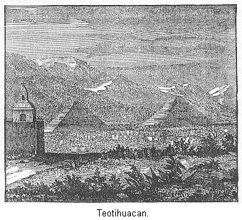
Still further to the north, about thirty miles
from Mexico, is found another extensive field of ruins, which is
called Teotihuacan, meaning "City of the Gods." The principal
ruins now standing are the two immense pyramids (which are
represented in this cut), which the natives call the "House of
the Moon" and the "House of the Sun." We will describe the
surroundings first. It is unquestioned but that here was a very
extensive settlement in early times. When the Nahua tribes
entered Mexico they probably found it inhabited. One very recent
writer thinks that "nowhere else in America can you find a more
imposing mass of ruins."14 He
estimates that it was "a city upwards of twenty miles in
circumference."
Other writers have also noticed its great
extent. According to Thompson, "the ruins cover an area very
nearly as large as that of the present City of Mexico, and the
streets are as distinctly marked by the ruins of houses."15 And in another place Mr. Charney tells
us "the city was of vast extent; and, without indulging in any
stereotyped reflections on the vanity of human greatness, I will
say that a more complete effacement is nowhere else to be seen.
The whole ground, over a space five or six miles in diameter, is
covered with heaps of ruins, which at first view, make no
impression, so complete is their dilapidation."16
Of this mass of ruins we are told but little,
beyond the general assertion that it consists of the ruins of
buildings, temples, etc. But very recently M. Charney has
uncovered the foundation of one of these houses. He calls it a
palace. It was, in all probability, a communal building. It had
two wings inclosing a court, and was located on a terraced
pyramid. He found, on digging into the terrace in front of the
ruins, a great number of sloping walls, covered with cement,
containing small compartments, etc. M. Charney can not account
for their presence.
In view of the discoveries further north, we
would respectfully suggest that this was, in reality, the lower
story of the building, whose flat roof formed the terrace in
front of the second story, whose foundation M. Charney so happily
discovered. But such suggestions as this are very unsafe to make,
and must be supported by further discoveries before they are of
any real value.
He found a large number of good-sized rooms,
and speaks especially of one hall fifty feet square, in the
center of which was six pillars, sloping from the base upwards.
They, doubtless, served to support the roof. We regret that we
have not been able to see M. Charney's ground plan of this ruin.
Of the pyramids themselves we have quite full information. The
larger one, that of the sun, is seven hundred and sixty feet
square and two hundred and sixteen feet high. It will be seen
that these dimensions throw the great mound at Cahokia into the
shade. Though the base may not be quite as great, the height of
the pyramid is over twice that of the mound. Three terraces are
plainly visible. The surface was covered with cement, large slabs
of which remain in their place. The moon pyramid is further
north.
It is in all respects like that of the sun,
but of smaller dimensions, being one hundred and fifty feet high.
In early times these pyramids are said to have supported statues,
but, if so, they have long since been thrown down. Their surface
and the ground around is thickly strewn with fragments of
pottery, obsidian knives, and other small relics. Running south
from the House of the Moon, and passing a little to one side of
the House of the Sun, are the remains of a wide, paved road. Its
width is stated to be one hundred and thirty feet, and its length
about two hundred and fifty rods.17
This road suddenly expands in front of the
Moon, so as to suggest the idea of a Greek cross. Pieces of
cement (with which this road was covered) are still visible in
places. It is lined with mounds on either side, and they stand so
close together as to resemble continuous embankments in some
places. Speculations are abundant as to the object of this graded
way. Tradition calls it the "Path of the Dead." Small mounds are
very numerous over the surface. They may have been for burial
purposes, but sculptured stones are found in them, and specimens
of hard cement. This group of ruins is regarded as of very great
antiquity.
We can easily see that the growth of the soil
formed by the decay and detrition of the stone slabs of the
pyramids, temples, and other buildings would be slow, especially
as the rainfall is light. But in some localities it is more than
three feet thick. In places three separate floors are observed,
one over the other, pointing to as many successive occupations of
the same sections by men.
About sixty-five miles to the north of Mexico
was located Tollan, or Tulla. According to tradition, this was
the capital city of the Toltecs, a mysterious people who long
preceded the Aztecs. We are told that "extensive ruins remained
at the time of the conquest, but very few relics have survived to
the present time."18 M. Charney,
whose labors we have referred to at Teotihuacan, succeeded also
in making important discoveries here. He tells us that on the
site of this ancient capital there is a hill, "about one mile
long by half a mile broad, covered with mounds, plateaus, and
ruins of all kinds."
He gives us the dimensions of two pyramids, as
follows. The first is one hundred and ninety-six feet on each
front, and forty-six feet high. The second is one hundred and
thirty-one feet square, and thirty-one feet high. Both of these
pyramids stood on raised foundations, which M. Charney calls
esplanades. As no other pyramids are mentioned, we are to suppose
these are the two principal ones. Perhaps they are also pyramids
of the sun and moon. Our chief interest is concerned with the
remains of the habitations he discovered here. He says: "I set
the men to work at one of the many mounds upon the ridge, and
soon found that I had hit upon a group of habitations." A general
idea of this group of buildings is given in this passage: "The
dwellings were united together in groups, and erected on isolated
mounds, one in the middle, the others around about, the whole
forming a sort of honey-comb, with its cells placed at different
elevations."
We can not help being struck with the general
resemblance of the descriptions here given and that of the ruins
in the vicinity of the River Gila. The general tendency is seen
to gather together in clusters, with, probably, the most
important house in the center. As to the materials used in this
building, we are told "they used clay and mud for the inside of
the walls, cement to coat them, dressed stone and brick for
casings, bricks and stone for stairways, bricks for pilasters,
and wood for roofing the edifice. The houses bad flat roofs,
consisting of timbers coated with cement. Of such timbers we find
vast quantities."19
Of the arrangements of the rooms, he tells us,
"The apartments that have been brought to light comprise a number
of chambers, big and little, placed at different heights. We
shall have no clear idea of the relation of these different
chambers to one another, or of the mode of access to them through
the labyrinthine passages and the numerous stairways, until the
whole edifice has been unearthed."
This was not the only building he discovered.
On digging into a mound supposed to be the support of a temple,
he discovered it was the ruined foundation of a still grander
house. He says, "It is much larger than the other one, stands on
a pyramid, and has two wings inclosing a courtyard. The walls are
thicker than those of the first habitation, and more strongly
built. The apartments, too, are larger, though arranged in a
similar fashion." Elsewhere he tells us that this building
contained at least forty-three apartments, large and small. We
presume very few will now question but what the buildings he here
describes are ruined communal buildings, much like the structures
in Arizona.
But perhaps the most interesting result of his
labors was the proof that these ruins were certainly inhabited
after the conquest—for how long a time we can not tell.
This is shown by fragments of bones and other articles found in
the refuse heaps. The bones were of such animals as the horse,
swine, sheep, oxen, etc.—animals introduced into this
country by the Spaniards. The fragments of pottery include
specimens plainly not of Indian manufacture, such as fragments of
porcelain, and that variety of glazed ware known as delf, and
lastly, the neck of a glass bottle. It may be said that these
fragments might have been left by a band of Spaniards who
occupied the ruins in the early days of the conquest, perhaps
long after the Indian owners had left. This is of course
possible, but it is just as reasonable to suppose the fragments
were left by descendants of the original builders.
Northward from Tulla is a small province,
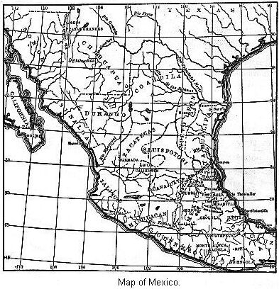
marked on the map Querataro. From the accounts at our disposal,
which are very brief, we gather that this whole section is a
tableland split up by ravines of great depths and precipitous
sides; consequently one abounding in easily defended positions.
It was found that all the projecting points, naturally strong,
were rendered still stronger by the presence of ditches, walls,
and embankments. Three groups of ruins are mentioned especially,
and their location is marked on the map. At Pueblito there was,
at an early day, plainly to be seen, the foundation of a large,
rectangular building. The walls were built of stone laid in
clay.
At Canoas, in the northern part of the State,
there is a steep and strongly fortified bill, but particulars in
regard to it are very meager. "There are, in all, forty-five
defensive works on the hill, including a wall about forty feet in
height, and a rectangular platform with an area of five thousand
square feet."20 Ranas, the most
northern one of the three sites mentioned, is regarded as the
center of population in early times. "A small lake and a
perennial spring are supposed to have been the attractions of
this locality in the eyes of the people. On all the hills about
are still seen vestiges of their monuments."
If we look at the map we will notice that we
have gone but a little ways north of the valley of Anahuac. Yet,
with the exception of the Gulf-coast, there are but few striking
aboriginal ruins in Northern Mexico. At the time of the conquest
the whole northern section was the home of tribes not generally
considered to be as far advanced as those who lived in the
section we have already described, and in regions further south.
Yet it is certainly hard to draw the line between the culture of
the two people. We are told that, these Northern tribes though
styled "dogs," and "barbarians," by the Southern tribes, were yet
"tillers of the soil, and lived under systematic forms of
government, although not apparently much given to the arts of
agriculture and sculpture."
This point is of considerable interest to us,
theoretically; for it is a question from whence came the various
Nahua tribes. We would naturally think, if they came from the
North, we ought to find evidence of their former presence in the
various Northern States of Mexico. We must remember, however,
that a migrating people are not apt to leave monuments until they
reach the end of their migration. Neither has the territory been
as carefully explored as it should be. What accounts we can
obtain of the remains in this section are certainly very meager.
But one place in Sonora do ruins occur, and they have never been
examined by competent personages.21 In Chihuahua occur ruins, evidently
the works of the same people as built the separate houses to the
west of the Rio Grande, in New Mexico.
These ruins have received the same name as
those on the Rio Gila—that is, "Casas Grandes," meaning
"Great House." This cut represents a view of these ruins. The
river valley is here about two miles wide, and is said to be very
fertile. Mr. Bartlett thinks there is no richer valley to be
found from Texas to California. This valley was once the seat of
a considerable population. Mounds are here found in considerable
numbers. Over two thousand are estimated as occurring in a
section of country sixty miles long by thirty in width.22 We wish we knew more about the mounds.
They are said to contain pottery, stone axes, and other
implements. It is possible, then, that these mounds are ruins of
separate houses. At any rate, such are the only kind of ruins
noticed in the upper part of this same valley by Mr.
Bandelier.
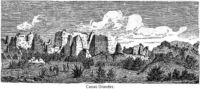
The ruins in question are undoubtedly those of
a rich and prosperous pueblo. They are so placed as to command a
very extensive view. The river valley is cut through a plain, and
has precipitous sides about twenty-five feet in height. The ruins
in question are found partly in the bottoms and partly on the
upper and more sterile plateau. The walls were made of adobe, and
in consequence of their long exposure to the elements are very
far gone in ruins; so much so that Mr. Bartlett was unable to
make out the plan. But enough was seen to show that this was a
pueblo much like the structure already described. They properly
belong to the Arizona group of ruins.
We are told they face the cardinal points, and
consist of fallen and erect walls. The portions still standing
are from fifty to sixty feet high, or rather were that height in
1851. It is doubtful whether any thing more than a mound of adobe
mud now marks the spot. The walls were highest in the center of
the mass. At the distance of a few miles was a hill said to be
fortified. But the descriptions of it are conflicting. Some
represent it as crowned with a stone-built fortress two or three
stories high. Others more reasonable, represent it as the site of
a watch-tower, or sentry station, and that at regular intervals
on the slope of the hill are lines of stone, with heaps of loose
stones at their extremities.23
Probably the same fate overtook the tribes of this valley as did
the sedentary tribes of the North. They would not willingly
abandon a place so well suited to their needs. The presence of an
invading foe, cruel and vindictive, alone accounts for this group
of ruins.
In Sinaloa we have no very definite account of
ruins. However, Mr. Bandelier says, the existence of ancient
villages in that section is certain, and that from "Sinaloa there
are ample evidences of a continuous flow Southward."24 There are no ruins worth mentioning in
any of the other States, excepting Zacatecas, where we find a
ruin of great interest. This is at Quemada, in the southern part
of the State. The name is taken from that of a farm in the near
neighborhood. The ruins are situated on the top of a hill, which
is not only naturally strong, but the approaches to it are
fortified. The hill ascends from the plain in a gentle slope for
several hundred yards, it then rises quite precipitously for
about a hundred and fifty feet. The total height of the hill
above the plain is probably not far from eight hundred feet.25
At all points where the approach to the top of
the hill is not steep enough to form a protection of itself, the
brow is guarded by walls of stone. This is especially true of the
northern end of the hill. One peculiar feature of this place is
the traces of ancient roads, which can still be clearly
distinguished crossing each other at various angles on the slope
we have mentioned. They can be followed for miles, and are
described as being slightly raised and paved with rough stones.
In places on the slope, their sides are protected by
embankments.
Considerable speculations have been indulged
in as to the purposes for which these roads were used. It has
been suggested that they were the streets of an ancient city
which must once have existed on the plains; and that the
fortified hill, with the ruins on its summit, was the citadel,
the residence of their rulers, and the location of their temples.
But we think a more reasonable view is that all of the city that
ever stood in that neighborhood was on the hill summit, and that
these streets were for religious purposes, reminding us in this
respect of the graded ways and traces of paved streets sometimes
met with in the Mississippi Valley. In proof of this view, it is
said that many of them, after being followed for a long distance,
are found to terminate in a heap of stones, which are evidently
the ruins of a regular pyramid. In opposition to both of these
views, it has been suggested that the surrounding plain was low
and marshy, and that the object of these causeways was to secure
a dry passage, which explanation is certainly very
reasonable.

Of the top of the hill, it may be sufficient
to state that it is of irregular shape, half a mile in length
from north to south, and of varying width, but on an average one
thousand feet wide. The approach to the top of the hill was
strongly guarded. Although buildings were observed covering the
whole top of the hill, yet they were in two principal groups.
This cut, though but one of many, will give us very good ideas of
all the ruins. It is seen to be an inclosure. It is on a small
scale. It was one hundred and fifty feet square. We notice
terraces on three sides. These terraces are three feet high by
twelve wide, and in the center of each side are steps by which to
descend to the square.26 Each
terrace is backed by a wall, portions of which are seen in the
engraving. These walls are twenty feet high by eight or nine in
thickness. The openings seen in the wall are not properly doors,
as they extend to the top of the wall.
This court, encompassed by terraces, is a
peculiar feature. It is different from any thing we know of,
either north or south.27 Courts,
surrounded by buildings located on terraces, are common enough,
but all accounts of these ruins say nothing of buildings. We
remember the inclosures that surrounded the houses clustered in
groups on the Rio Gila. We think this comes near to being a
development of the same idea. The low walls of the former
inclosure are here quite pretentious pieces of masonry. In some
cases two or more of these inclosed courts are joined by
openings.
The opening in the wall on the right of the
engraving leads into a perfect inclosed square of two hundred
feet. In one case a range of pillars was noticed parallel with
the walls, and distant twenty-three feet. These are supposed to
have supported the roof of the portico, and houses of a rude
description might have been ranged along under this roof, which
has since completely vanished. Back of this square, but not very
well shown on the drawing, rises a precipitous hill. A pyramid is
placed in the center of the side towards the hill. It is only
nineteen feet high,28 but is
divided into five stages or stories.29
This pyramid will serve as an example of
numerous other pyramids scattered over the summit of the hill.
They are made of stone. The largest one, whose dimensions are
given, is fifty feet square, and the same in height. In front of
the pyramid, and in the center of the square, are the remains of
an altar. In view of the altar and pyramid, within the inclosed
square, we may suppose this to have been dedicated to their
religion. As if to confirm this belief, is the statement that on
the hill to the back of the pyramid are numerous tiers of seats,
either broken in the rock or built of rough stone. The people
seated on them would be conveniently located as regards both
sight and hearing of what transpired there.
From an Indian's point of view, this hill was
very strongly fortified. It would be almost impossible for an
enemy to capture the settlement on its summit. The surrounding
country was probably fertile, and a large body of Indians could
have lodged within the fortified inclosures. It has some peculiar
features, which have been pointed out. There is now no water on
the hill, but traces of what is supposed to be an aqueduct are
observed, as well as several tanks, and at one place a well.
There is not an appearance of great antiquity about these ruins,
and yet native traditions are silent in regard to them, and but
one of the early writers refers to them, and he had not seen
them.30
West of the central basin the remains are more
numerous than to the north, but they are not very striking, and
it is scarcely worth our while to stop and examine them. About
sixty miles in a south-easterly direction from Mexico is the
modern town of Cholula. This has grown at the expense of the
ancient city of Cholula, grouped around the famous pyramid of
that name. This was the Mexican "Tower of Babel." The traditions
in regard to it smack so strongly of outside influence that but
little reliance can be placed on them. They are evidently a
mixture of native traditions and Biblical stories. Like
Teotihuacan and Tulla, this is regarded as a relic of Toltec
times. This is but another way of saying that it is older in time
than the majority of ruins.
At the time of Cortez's march to Mexico
Cholula was a very important place. In his dispatches he says:
"The great city of Cholula is situated in a plain, and his twenty
thousand householders in the body of the city, besides as many
more in the suburbs." He further states that he himself counted
the towers of more than four hundred "idol temples."31
We must remember that this is a Spanish
account, and therefore exaggerated. Still, after making due
allowance for the same, it would remain an important aboriginal
settlement. We have no reliable data of the population at the
time of the conquest. From documentary evidence Mr. Bandelier has
shown that while Cholula was certainly a populous Indian pueblo,
it is a misnomer to call it a city. It was a group of six
distinct clusters, gathered around a common market. He estimates
that its population may possibly have been thirty thousand.32 All explorers have mentioned the
fertility of the plain in the midst of which this monument is
found.
But this plain is almost destitute of easily
defended positions; which fact has an important bearing on the
purpose for which the great mound was erected. At a distance it
presents all the appearance of a natural hill. The casual
observer would not believe it was entirely the work of men. "In
close proximity," says Mr. Bandelier, "the mound presents the
appearance of an oblong conical hill, resting on projecting
platforms of unequal length. Overgrown as it is with verdure and
partly by trees, and with a fine paved road leading to the
summit, it looks strikingly like a natural hill, along whose
slopes the washing of the rains and slides have laid bare bold
bluffs, and into whose bulk clefts and rents have occasionally
penetrated."
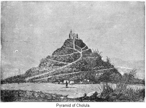
This celebrated mound or pyramid has lately
been the subject of a very careful study by Mr. Bandelier. The
illustration we present gives us a very good idea of the present
appearance of the mound. The mass is probably solid throughout,
and if there is a natural hill in its center, it must be a very
small one. The height of the central higher mass is very nearly
two hundred feet.33 The present
appearance of the summit is entirely due to the Spaniards. At the
time of the conquest the summit was convex; the friars had it
leveled in order to plant a cross. The area of this upper
platform is not far from two-thirds of an acre. It is now paved
and surrounded by a wall.
In the illustration we detect the appearance
of terraces. These are level areas, not all of the same height;
neither do they extend entirely around the mound. In fact, the
present appearance indicates three projections, or aprons,
surrounding and supporting a conical hill, and separated from
each other by wide depressions. This central mound, with its
three projections, rests upon a very extensive platform, which
was probably cross-shaped. This platform seems to have been about
twelve feet high, and covered an area of at least sixty
acres.
The object for which this great pile was
erected is a topic that has exercised the thoughts of many
scholars. Some have supposed it was a burial mound. Some years
ago, while in constructing a road from Pueblo to Mexico, the
first terrace or story was slightly dug into, and disclosed a
chamber, which contained two skeletons, two idols, and a
collection of pottery. Yet, before deciding it to be a burial
mound, it will be necessary to show the presence of tombs near
the center.
We have referred to the results of Mr.
Bandelier's explorations. He made a very thorough study of this
great pyramid—more complete than any that had hitherto been
made—and his results should have corresponding weight. He
finds that the materials of which the adobe brick is composed are
exactly the same as that of the surrounding plain. This does away
with one old tradition, that the bricks were manufactured at a
distance, and brought several leagues to their destination by a
long line of men, who handed them along singly from one to
another.
From the manner in which the bricks are laid,
and from their variation in size, he concludes that the structure
was not all erected at one time, but that the mound is the
accumulation of successive periods of labor. From this it follows
that it was built to serve some purpose of public utility, and
not as a token of respect for some individual. Wherever found,
these great works show the same evidence of not being all
completed at once. This was true of the North; we shall also find
it true of the South. Charney noticed the same thing in the house
at Tulla. Nothing is more natural than that an Indian community
would increase their buildings as the tribe increased.
Mr. Bandelier's final conclusion in regard to
the purpose of its erection is one of great interest, but not at
all surprising. "If we imagine the plateaus and aprons around it
covered with houses, possibly of large size, like those of Uxmal
and Palenqué,34 or on a
scale intermediate between them and the communal dwellings of
Pecos and many other places in New Mexico,35 we have then, on the mound of Cholula,
as it originally was, room for a large aboriginal population. The
structure, accordingly, presents itself as the base of an
artificially elevated, and therefore, according to Indian
military art, a fortified, pueblo."
But this does not remove from it the air of
mystery. Long-fallen indeed are the communal walls. It was not
simply a few years ago that these pueblo-crowned terraces were
reared. The date of its erection is hid in the dim traditions of
the past. The traditions of the Nahua tribes, who came at a far
later date, speak of it as even then standing on the plain.
Scattered over the plain are other ruins of a somewhat different
nature from the general ruins in the valley. These may be the
ruins of works erected by the same class of people as built the
mounds. Especially is this thought to be true of ruins found on
the slopes of neighboring volcanoes.
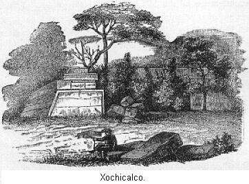
To the south-west of Cholula are the ruins of
Xochicalco, which, by some, are pronounced to be the finest in
Mexico. There are many points of resemblance between this ruin
and Tezcocingo. The meaning of the word is "Hill of Flowers." The
hill is a very regular, conical one, with a base nearly three
miles in circumference, and rises to a height above the plain of
nearly four hundred feet.36 The
hill is considered to be entirely a natural formation; but it
probably owes some of its regular appearance to the work of man.
Around the base of the hill had been dug a wide and deep ditch.
When Mr. Taylor visited the place, the side of this moat had
fallen in, in many places, and in some quite filled up—but
it was still distinctly visible.37 The whole surface of this hill was
laid off into terraces.
Five of these terraces, paved with blocks of
stone laid in mortar, and supported by perpendicular walls of the
same material, extend, in oval form, entirely around the whole
circumference of the hill, one above the other. From the
accumulation of rubbish, these terraces are not easy to detect in
all places. Probably, at one time, there was some easy means of
access from one terrace to the other, but they have
disappeared—so that now the explorer has to scramble up
intervening slopes of the terraces as best he can. It is probable
that defensive works once protected these slopes.
Mr. Mayer says: "At regular intervals, as if
to buttress these terraces, there are remains of bulwarks shaped
like the bastions of a fortification."38 "Defense seems to have been the one
object aimed at by the builders." The top of the hill is leveled
off. Some writers represent that a wall of stone was run along
the edge of the summit but others think that the whole top of the
hill had been excavated, so as to form a sunken area, leaving a
parapet along the edge. This summit-platform measured two hundred
and eighty-five feet by three hundred and twenty-eight feet.
Within this area were found several mounds and heaps of stones.
The probabilities are that it was once thickly covered with
ruins. In the center of this sunken area are the remains of the
lower story of a pyramid, which the inhabitants in the vicinity
affirm to have been once five stories high.
To judge from the ruins still standing, this
must have formed one of the most magnificent works of aboriginal
skill with which we are acquainted. This cut gives a general idea
of the ruins from the west. We presume the broken appearance
presented by this side is in consequence of the removal of stones
by planters in the vicinity for their own use. It seems they have
used this monument as a stone-quarry. This pyramid, or the first
story of it, was nearly square—its dimensions being
sixty-four feet by fifty-eight.
The next cut is an enlarged drawing of the
north-west corner seen in the first drawing. Notice the grotesque
ornamentations on it. The ornaments are not stucco-work, but are
sculptured in bas-relief. As one figure sometimes covers parts of
two stones, it is plain they must have been sculptured after
being put in position. The height of this front is nearly fifteen
feet. In the left-hand corner of this sculpture will be perceived
the bead of a monstrous beast with open jaws and protruding
tongue. This figure is constantly repeated in various parts of
the façade. Some have supposed it to be a crocodile. The
rabbit is another figure that constantly reappears in portions of
the wall.
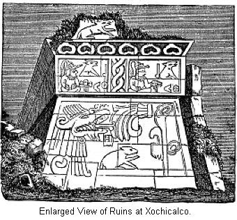
We can scarcely realize the labor involved in
the construction of this pyramid and the terraced slope. Some
idea may be formed of the immense labor with which this building
was constructed from measurements made of several of the masses
of porphyry that compose it. One stone was nearly eight feet long
by three broad. The one with the rabbit on is five feet by two
and a half. When it is recollected that these materials were not
found in the neighborhood, but were brought from a great
distance, and borne up a hill more than three hundred feet high,
we can not fail to be struck with the industry, toil, and
ingenuity of the builders, especially as the use of beasts of
burden was, at the time, unknown in Mexico. Nor was this edifice,
on the summit, the only portion of the architect's labor. Huge
rocks were brought to form the walls supporting the terraces that
surrounded the hill, a league in circumference, and the whole of
that immense mass was eased in stone. Beyond these terraces,
again, there was still another immense task in the ditch, of even
greater extent, which had to be dug and regularly embanked.39
Now, what was the object of all this labor?
This must have been the center of a large settlement. It seems
that the surrounding hills—or, at least, some of
them—were also terraced. Mr. Taylor says: "On the
neighboring hills we could discern traces of more terraced roads
of the same kind. There must be many miles of them still
remaining." In a Mexican book we are told "adjoining this hill is
another higher one, also covered with terraces of stone-work in
the form of steps. A causeway of large marble flags led to the
top, where there are still some excavations, and among them a
mound of large size." Mr. Latrobe, from the top of the "Hill of
Flowers," saw that it was the center towards which converged
several roads, which could be traced over the plain. The road he
examined was "about eight feet in breadth, composed of large
stones tightly wedged together." It is extremely probable that in
Xochicalco we have another instance of a strongly fortified hill,
on the top of which was their pueblo, arranged around their
teocalli, or temple.40
In our description of this ruin we must not
forget to mention some curious underground chambers, excavated in
the hill itself. On the northern slope, near the foot, is the
entrance to two galleries, one of which terminated at the
distance of eighty feet. The second gallery is cut in solid
limestone, about nine feet square, and has several branches. The
floors are paved with brick-shaped blocks of stone. The walls are
also, in many places, supported by masonry, and both pavement,
walls, and ceilings are covered with lime-cement, which retains
its polish, and shows traces, in some parts, of having had
originally a coating of red ocher. The principal gallery, after a
few turns, finally terminated, or appeared to, in a large room
eighty feet long, in which two pillars were left to support the
roof. In one corner of this room there was a dome-shaped
excavation in the roof, from the apex of which a round hole about
ten inches in diameter extended vertically upwards.
The natives say there are still other
excavations. We have seen no good explanation of the uses of
these excavations. The labor in constructing them must have been
very great. In the province of Oaxaca we shall find several
groups of ruins. In all probability those known and described are
not more numerous than those unknown. The class of ruins
represented by Quemada, Tezcocingo, and Xochicalco (that is, a
hill strongly fortified, with traces of a settlement on the
summit, mounds, foundations of communal houses, and pyramidal
structures) are also to be found here. At Quiotepec we have very
meager accounts of such a ruin. The hill is over two miles in
circumference and a thousand feet high. A running stream has
rendered one side of the hill very steep and precipitous, but the
other sides are terraced.
One of the terrace-walls at the summit is
about three hundred and twenty feet long, sixty feet high, and
five and a half feet thick.41 On
the summit of the hill are found great numbers of mounds,
foundations of small buildings, as well as ruins of statelier
buildings, called by some palaces, but which were probably
regular communal structures; also the pyramid base of a temple.
At different points near the summit of the hill are three tanks
or reservoirs, one of which is sixty feet long, twenty-four feet
wide, and six feet deep, with traces of steps leading down into
it.
Still further south, near the center of the
state at Monte Alban, is a more extensive group of ruins on the
same general plan as the one just described. In this case, from
the banks of a stream, there rises a range of high hills with
precipitous sides. At their summit is an irregular plateau half a
mile long by nearly a quarter of a mile wide. M. Charney states
that a portion of this plateau is artificial. He represents the
whole surface as literally covered with blocks of
stone—some sculptured—the ruined foundations of
buildings, terraces, and so forth. He regards it as one of the
most precious remains of aboriginal work, and this is the view of
Mr. Bandelier also. It is to be regretted that we have not more
details of such interesting ruins. We, however, would learn but
little new from them. One ruin is spoken of as an immense square
court, inclosed by four long mounds, having a slight space
between them at the ends. It is extremely probable that these
mounds once supported buildings.
The most celebrated ruin in Oaxaca is Mitla.
These are the first ruins we have met that, by their strange
architecture and peculiar ornamentation, suggest some different
race as their builders. The present surroundings are of the
gloomiest character. The country is barren and desert. The valley
in which the ruins are located is high and narrow, but surrounded
by bleak hills. The soil is dry and sandy, and almost devoid of
vegetation. The cold winds, blowing almost constantly, sweep
before them great clouds of sand. A small stream flows through
this dreary waste, which, during the rainy season, is a raging
torrent. "No birds sing, or flowers bloom," around these old
ruins. Appropriately enough, tradition speaks of this as the
"Place of Sadness," or "Dwelling of the Dead." As to the extent
of territory covered by the ruins, we have not been able to learn
further than the general statement that at the time of the
conquest they covered an immense area.42
 Mr.
Bandelier found, besides two artificial hills, traces of
thirty-nine distinct edifices, and, as he thinks these are all
the buildings that ever stood there, it is manifest that this was
not a city in our sense of the word. Two or three of the
buildings were constructed of adobe, plastered, and painted red.
The others were built of stone. Of these latter the greater part
stands upon the ground, but a few are built upon elevated
terraces, composed of stone and earth heaped together and faced
with stone. In one group of four buildings the terraced
foundation contained a basement—in one case, at
least—in the form of a cross. The purpose of this cellar or
basement left in the artificial foundation is unknown. Some think
they were used for burial purposes but it is more likely they
were general store-rooms. The arrangement of these buildings was
the same as elsewhere. That is, so placed as to inclose a court.
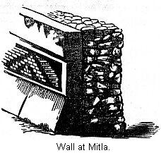
This illustration shows us the method of constructing the walls
of the building. We notice two distinct parts. The inner part is
built of broken stones laid in tolerably regular courses in clay.
There was no mortar used. This inner core is much the same sort
of work as the masonry in the pueblos of Arizona. A facing was
put on over this inner core, which served both for ornament and
for strength. This illustration is a corner of one of these
buildings, and gives us in excellent idea of the peculiar
ornamentation employed at Mitla. Mr. Bancroft gives us a clear
idea of how this facing was put on: "First, a double tier of very
large blocks are placed as a base along the surface of the
supporting mound, projecting two or three feet from the line of
the wall, the stones of the upper tier sloping inward. On this
base is erected a kind of framework of large, hewn blocks with
perfectly plain, unsculptured fronts, which divide the surface of
the wall into oblong panels of different dimensions."43
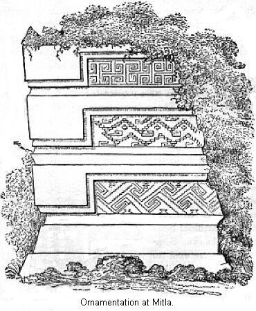
It would, then, seem as if the panels were
thickly coated with clay. Into this clay was then driven small,
smoothed blocks of wedge-shaped stones, in such a way as to cover
them with geometrical ornamentations, which, though not
absolutely symmetrical, present a striking and agreeable
appearance. Each section of the wall presents a different
pattern, but this difference is so slight that the general effect
is harmonious.44 This mosaic
ornamentation is found in some of the inner facings of the walls
as well. In general, however, the walls on the inside were
covered with mortar and painted.
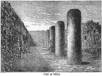
Some of the blocks of stone forming the
basement, the framework of the panels, and the lintels of the
door are of great size, and the lintels were in some cases
sculptured. One of the largest rooms at Mitla is represented in
the preceding cut. The peculiar feature about it is the range of
columns seen in the drawing. The inner plastering has fallen,
exposing the rough wall. The columns are simple stone pillars,
having neither chapter nor base. It is generally supposed that
these pillars supported the roof. As in the pueblo buildings to
the north, as well as the Toltec house at Tulla, the roof was
probably formed of the trunks of small-sized trees laid close
together and covered with clay and cement.
We have as yet not seen any thing in these
ruins sufficiently striking to justify the somewhat extravagant
assertion made about them. The ornamentation is indeed peculiar
and tasteful, but aside from that, we see no reason to speak of
them as magnificent structures. The buildings are low and narrow;
the rooms are small, dark, and illy ventilated. "Light could only
have been admitted from one side, and the apertures for this
purpose were neither lofty nor broad." Mr. Bandelier fittingly
characterizes the ruins as the "barbaric effort of a barbarous
people." Those scholars who think we have in Mexico the ruins of
a highly civilized, powerful empire, regard these ruins as in
some way set aside for mourning purposes of the royal family.
"According to tradition," says Mayer, "They were . . . intended
as the places of sepulture for their princes. At the death of
members of the royal family, their bodies were entombed in the
vaults beneath; and the sovereign and his relatives retired to
mourn over the departed scion in the chambers above these solemn
abodes, screened by dark and silent groves from the public eye."
Another tradition devotes the edifices to a sect of priests,
whose duty it was to live in perfect seclusion, and offer
expiatory sacrifices for the royal dead who reposed in the vaults
beneath.45
With all due respect to traditions, we think a
much more reasonable explanation can be given. One reason why
Mitla has been regarded as such an important place, is because it
has been assumed that there were no other ruins like it,
especially in Mexico. This, according to Mr. Bandelier, is a
mistake. He examined one or two quite similar ruins in the near
vicinity, and at another place he found a group of ruins in every
way worthy of being compared to Mitla, but he was not able to
examine them. So we must either decide there were a number of
these "Sepulchral Palaces," or else adopt some simpler
explanation. But still stronger is the fact, that at the time of
the conquest, Mitla was an inhabited pueblo. We have the account
of a monk who visited it in 1533. He mentions in particular the
ornamentation of the walls, the huge doorways, and the hall with
the pillars. It is extremely probable that if it was devoted to
any such purpose, some mention would have been made of it. We
think Mr. Bandelier is right when he concludes that these
structures are communal buildings, but little different from
others.
As for the other ruins in Oaxaca, we will not
stop longer to examine them. At Guingola, in the southern part of
the State, was found a ruined settlement. The principal ruins
were located on the summit of a fortified hill, which, from a
brief description, must have been much like those we have already
described.
We will now turn our attention to the
Gulf-coast. The whole coast region abounds in great numbers of
ruins. It is in this section, however, that tribes of people
belonging to a different family than the Nahua tribes, were
living at no very distant time in the past. So it is not doubted
but that many of these ruined structures, perhaps the majority of
them, were the works of their hand. When Cortez landed on the
coast, in the neighborhood of Vera Cruz, he was received by the
Totonacas. These were a Nahua tribe, but both to the north and
south of them were Maya tribes.46
We will, however, describe the ruins in the present State of Vera
Cruz under one head.
We notice, on the coast, the Gulf of Tampico,
into which pours the river Panuco. From an antiquarian point of
view, this is a most interesting locality. It was here that a
feeble remnant of De Soto's disastrous expedition found a refuge
in 1543. And it was here that, at a far earlier period, according
to the dim, uncertain light of tradition, the ancestors of some
of the civilized nations of Mexico made their first appearance;
of this, more hereafter. Certain it is that, commencing at this
river, we find ourselves in a land of ruins.
It is to be regretted, however, that our
information is not definite in regard to them. We are told, in
general terms, of a great field of ruins, but in the absence of
cuts, can scarcely give a clear description of them. On the
northern bank of the Panuco, Mr. Norman found at one place the
ground "strewn with hewn blocks of stone and fragments of pottery
and obsidian."47 They were found
over an area of several square miles. Many of the blocks of stone
were ornamented with sculpture. They imply the presence, in
former times, of some kind of buildings. We can not form an
opinion as to the number, style, etc. Mr. Norman regards them as
the ruins of a great city, the site of which is now covered with
a heavy forest.
Amongst these ruins are about twenty mounds,
both circular and square, from six to twenty-five feet in height.
Some authorities think that the Mound Builders went by water from
near the mouth of the Mississippi to this region. To such as
place any real reliance on this theory, these mounds are full of
interest. But some details of construction would seem to indicate
a different people as their builders than those who reared mounds
in the Gulf States of the Mississippi Valley. The main body of
the mound is earth, but they are faced with hewn blocks of
sandstone, eighteen inches square and six inches thick. Although
one of the mounds is quite large, covering two acres, yet in but
one instance was a terraced arrangement noticed. As a general
thing, the facing of stone had fallen to the ground, and some of
the smaller mounds had caved in; showing, perhaps, that they were
used as burial mounds. In other cases the mounds had entirely
disappeared, leaving the stone facing on the surface. This may
account for some of the stones scattered over the surface. A few
miles away there is another group of circular mounds.
Across the river in Vera Cruz, from very
slight mention, we gather that, substantially, the same kind of
ruins occur. At Chacuaco the ruins are said to cover three square
leagues—but we have no further account of them than that.
Small relics of aboriginal art are said to be common, and mention
is made of mounds. The antiquities of Vera Cruz are a topic about
which it is very difficult to form correct ideas. It will be
noticed that it presents a long stretch of country to the Gulf.
The land near the coast is low, and very unhealthy. About thirty
miles from the coast we strike the slope of the mountains
bounding the great interior plateau. This section is fertile and
healthy, and was, evidently, thickly settled in early times. We
must remember that it is always in a mountainous section of
country that a people make their last stand against an invading
foe. It was in these mountain chains where the Maya tribes made
their last stand against the invading Nahua tribes, and even this
line was pierced through by the Tonacas.
It is not strange, then, to find abundant
evidence of former occupation in all this section of country. One
thing in its favor was the number of easily defended positions.
The country is cut up by deep ravines. The early inhabitants used
all the land that was at all available for agricultural purposes.
On steep slopes they ran terraces to prevent the soil from
washing. In the smaller ravines they located great numbers of
water-tanks, from which, in the dry season, they procured water
to irrigate their land. Of this section, we are told, "there is
hardly a foot of ground in the whole State of Vera Cruz in which,
by excavation, either a broken obsidian knife, or a broken piece
of pottery, is not found. The whole country is intersected with
parallel lines of stones, which were intended, during the heavy
showers of the rainy season, to keep the earth from washing away.
The number of these lines of stones shows clearly that even the
poorest land, which nobody in our day would cultivate, was put
under requisition by them."48
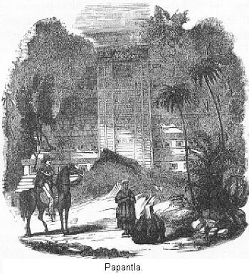
They no less conclusively show that a
considerable body of people had here been pressed by foreign
invasion into a small, contracted space. It is useless to attempt
a more particular description of these ruins. In the absence of
cuts, the description would only prove tiresome. Pyramids, both
with and without buildings on their summits, are comparatively
frequent. As they would be noticed where other ruins would be
overlooked, we have some cuts of the more remarkable ones. The
preceding cut is the pyramid at Papantla.
The base is ninety feet square, and the
pyramid has seven stories, as seen in the engraving. Only the
last one contains apartments; with this exception, the pyramid is
solid. Stairways in front lead up to the top. Mr. Mayer says
"there is no doubt, from the mass of ruins spread over the plain,
that the city was more than a mile and a half in circuit." But we
have no further description of them. Other localities with
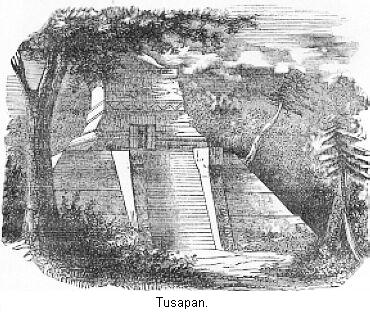
pyramids and ruins are known. At Tusapan occurs this ruin, which
may be taken as a type of all the pyramids in this region. This
was the only building remaining standing at Tusapan; but, from
the ruins lying about, this is not supposed to have been the
grandest structure there.
This will complete what we have to say of the
ruins in territory occupied by the Nahua tribes. Other remains of
their handiwork we will examine when we treat of their customs
and manners. We will now turn our attention to the ruins in the
territory of the Mayas. As the culture of these two people is so
similar, we will devote but one chapter to the two. Comparison is
the great means we have of fixing in the mind points we wish to
keep. We have to admit that the treatment of the Nahua ruins is
not very satisfactory; but it is difficult to obtain accurate
information in regard to them. We think what resemblance can be
traced, is more in the direction of the Pueblo tribes than of the
Mound Builders. The first ruin found in Mexico, Casa Grandes, in
Chihuahua, is evidently but another station of Pueblo tribes.
The fortified hill at Quemada is apparently
but a further development of the clustering houses with the
little inclosures noticed on the Gila. Mounds are, indeed,
mentioned in a number of localities, but they seem to be more
nearly related to the terraced foundation of buildings observed
in Arizona than to the mounds of the Mississippi Valley. Surely
as striking a ruin as any is at Mitla, but Mr. Bandelier does not
hesitate to compare it with some in the Pueblo country. Now, it
is very unsafe and very unsatisfactory to trace resemblances of
this kind, and we do not assign any especial value to them. But
it only shows that, so far as this method is of use, it points to
a closer connection with the Pueblo tribes than with the Mound
Builders.
REFERENCES
- Gregory's "History of Mexico," p. 19.
- Bancroft's "Native Races," Vol. II, p. 92.
- The Tierra Caliente.
- Ober's "Mexican Resources," p. 2.
- "Mexico As It Was," p. 221.
- "Six Months in Mexico," p. 386.
- Mayer: "Mexico As It Was," p. 234.
- Thompson's "Mexico," p. 144.
- Bancroft: "Native Races," Vol. IV, p. 526.
- "Rambles in Mexico," p. 140.
- "Gratacap, in American Antiquarian, October, 1883, p.
310.
- "Native Races," Vol. II, pp. 168-173.
- As to this hill, Mr. Bandelier remarks: "As a salient and
striking object, and on account of the freshwater springs,
Chapultepec was worshiped, but I find no trace among older
authors of any settlement there—still less of a Summer
palace— at the time of the conquest." "Report of an
Archæological Tour in Mexico," p. 73.
- Charney in North American Review, September, 1880, p.
190.
- "Recollections of Mexico," p. 140.
- We have several times remarked that it is not safe to judge
prehistoric population by the amount of ruins. "Indians never
rebuild on ruins or repair them."
- Bancroft: "Native Races," Vol. IV., p. 537.
- Bancroft: "Native Races," Vol. IV, p. 547.
- The ceilings in the pueblos of Arizona were often made of
poles covered with cement. See Chapter XI.
- Bancroft's "Native Races," Vol. IV, p. 550.
- Bandelier: "Fifth Annual Report Arch. Inst.," p. 86.
- Bancroft's "Native Faces," Vol. IV, p. 610.
- Bancroft's "Native Races," Vol. IV, p. 613.
- "Fifth Annual Report," p. 86.
- Bancroft's "Native Races," Vol. IV, p. 581. These dimensions
are different in different accounts, as may be seen by consulting
Mr. Bancroft's work.
- Lyons's Journal. From Mayer's "Mexico As It Was," p.
243.
- There is something of a similarity between these ruins and
those of the coast tribes of Peru.
- Another authority states that it is thirty feet square and
thirty feet high. Bancroft: "Native Races," Vol. IV, p. 587,
note.
- As seen in the Drawing. Mr. Lyons states there are seven
stories.
- This was Clavigaro. Mayer's "Mexico As It Was," p. 245.
- Thompson's "Recollections of Mexico," p. 29.
- "An Archæological Tour in Mexico," p. 163.
- The altitude varies according to the side where the
measurement is taken. The average height is about one hundred and
seventy feet.
- To be described hereafter.
- See Chapter XI.
- Different explorers give different figures.
- Taylor's "Anahuac," p. 184.
- "Mexico As It Was," p. 180.
- Mayer: "Mexico As It Was," p. 184.
- This is in strict keeping with what we have seen to be true
of their pueblo sites. This is the conclusion of Mr. Bandelier,
who discusses this subject in his essay on "Art of War Among the
Mexicans." Peabody Museum Reports, Vol. II, p. 146, note
186.
- Bancroft: "Native Races," Vol. IV, p. 419.
- Bancroft's "Native Races," 393, note.
- Bancroft's "Native Races," Vol. IV, p. 395.
- Bandelier: "An Archæological Tour in Mexico," p.
295.
- Mayer: "Mexico As It Was," pp. 251-2.
- Valentine, in "Proceedings Am. Antiq. Soc.," Oct., 1882.
- Bancroft's "Native Races," Vol. IV, p. 595.
- "Smithsonian Report," 1873, p. 373.
Chapter XII: The Prehistoric
Americans.
Chapter XIV: The Maya Tribes.
 THE ships of the Spanish
admiral came to anchor before the Island of San Salvador, he had
indeed discovered a "New World." It was inhabited by a race of
people living in a state of society from which the inhabitants of
Europe had emerged long before the dawn of authentic history. The
animal and plant life were also greatly different from any thing
with which they were acquainted. The Spaniards little suspected
the importance of their discovery. Columbus himself died in the
belief that he had simply explored a new route to Asia. A quarter
of a century elapsed after the first voyage of Columbus before an
expedition coasted along the shores of Mexico. This was the
expedition of Juan De Grijalva, in 1518. He gave a glowing
description of the country he had seen, which "from the beauty
and verdure of its indented shores, and the lovely appearances of
its villages, he called 'New Spain.'"1


 Mr.
Bandelier found, besides two artificial hills, traces of
thirty-nine distinct edifices, and, as he thinks these are all
the buildings that ever stood there, it is manifest that this was
not a city in our sense of the word. Two or three of the
buildings were constructed of adobe, plastered, and painted red.
The others were built of stone. Of these latter the greater part
stands upon the ground, but a few are built upon elevated
terraces, composed of stone and earth heaped together and faced
with stone. In one group of four buildings the terraced
foundation contained a basement—in one case, at
least—in the form of a cross. The purpose of this cellar or
basement left in the artificial foundation is unknown. Some think
they were used for burial purposes but it is more likely they
were general store-rooms. The arrangement of these buildings was
the same as elsewhere. That is, so placed as to inclose a court.
This illustration shows us the method of constructing the walls
of the building. We notice two distinct parts. The inner part is
built of broken stones laid in tolerably regular courses in clay.
There was no mortar used. This inner core is much the same sort
of work as the masonry in the pueblos of Arizona. A facing was
put on over this inner core, which served both for ornament and
for strength. This illustration is a corner of one of these
buildings, and gives us in excellent idea of the peculiar
ornamentation employed at Mitla. Mr. Bancroft gives us a clear
idea of how this facing was put on: "First, a double tier of very
large blocks are placed as a base along the surface of the
supporting mound, projecting two or three feet from the line of
the wall, the stones of the upper tier sloping inward. On this
base is erected a kind of framework of large, hewn blocks with
perfectly plain, unsculptured fronts, which divide the surface of
the wall into oblong panels of different dimensions."


